Early last week I caught wind of a few co-workers who were planning to take advantage of the sunny weather by ditching work on Friday for a ski trip to Mount St. Helens. As any loyal reader of this blog will know, I already skied Mount St. Helens earlier this year, so I lobbied for a change of venue to Mount Shuksan which has been on my list all winter. The others were easily convinced, and on Thursday afternoon at 4:00pm Redwood, Jeff, and I loaded up Redwood's VW bus with our climbing and skiing gear and chugged north on I-5 towards Mount Shuksan. We made a short stop in Mount Vernon for a visit to Redwood's favorite food Co-op so that he could stock up on organic nuts (while claiming that he isn't a hippie), after which the VW bus wouldn't start so Jeff and I had to get out and push until we gained enough momentum to bump start it. Eventually we were on our way again, and before too long we were driving up the logging road about Baker Lake towards the Shannon Ridge Trailhead where our ascent would begin.
We were forced to stop and park before reaching the trail head by snow on the road; this was bad news in that it made our trip longer but good news in that we wouldn't have to do much walking in our ski boots before donning our skis. At this point it was about 8:00pm or so, and we quickly packed up our gear and suited up so that we could make some progress before darkness fell:

After a short chat with a crazy hermit who was making dinner near our parking spot we started heading along the road towards the trailhead. It wasn't long before darkness fell, so we switched on our headlamps and continued along the trail. Our plan was to make as much headway as we could that night before setting up camp and grabbing a few hours of sleep before continuing on early the next morning. I had the pleasure of using my converted Petzl Zoom headlamp which I wrote about a while ago, I still need to write a more exhaustive report on my final design but let's just say it has turned out to be a real barn-burner of a headlamp. Eventually the periodic bare patches disappeared and we began to make good headway on the solid snow, following tracks from a guided party who had headed up a few days earlier (we had seen their van parked at the trailhead). Here are Redwood and Jeff heading up the trail past one of the wands left by
the guided party:

Around midnight we topped out on a ridge that appeared to be near the top of the treeline, after continuing a little further along the ridge we decided to stop and set up camp since it looked like one of the last sheltered spots that we would encounter. We had started at 2,300 feet of elevation and our campsite at the end of the ridge was at 4,900 feet of elevation so we were happy with our progress that night. Here are Jeff and Redwood starting to set up camp:

Redwood fired up the stove for some late night dinner while Jeff and I set up the tent, here is a shot of our nicely sheltered tent site with me in the foreground conducting some experimental night-photography with my tripod (unfortunately none of the resulting photos made the cut for this blog post).

After the tent was set up we gathered round Redwood's supercharged stove (he had designed it while working at MSR and explained at great length the virtues of its design; unfortunately I understood exactly none of his explanations so I am at a loss to recount them here) for some pasta and mushrooms with pesto that Jeff had kindly procured the night before. By the time we had wrapped up the dinner festivities it was 2:00am and time for bed so we crawled into our sleeping bags and did our best to nab a bit of shuteye before resuming our climb.
Our alarm went off 2 hours later at 4:00am, and we blearily rubbed our eyes and forced ourselves out of our sleeping bags. It was surprisingly light at this hour which made things a bit easier, here is a shot of the tent illuminated from within by someone's headlamp:

After pulling on our frozen ski boots we debated about whether or not we should make breakfast; the debate ended quickly after Jeff pointed out that we had just eaten dinner two hours earlier. So, after Redwood melted some snow for a bit of instant coffee we loaded up our packs and headed out, leaving the tent and our sleeping bags inside to be retrieved on our way back down the mountain. From the ridge we had camped on we headed up a steep section to gain a saddle, made trickier by the frozen crust on the snow which didn't allow good skin traction. I quickly donned my ski crampons having been in this situation previously, they helped considerably. We shortly gained the saddle where we were greeted by the guided party who had camped there and were just starting to make breakfast, and we were also greeted by the sunrise peeking over the mountains to the east:

We also had good views of Mount Baker to the west in the pre-morning light:

The guided party informed us that a foot of fresh snow had fallen the day before and they had not been able to summit Mount Shuksan due to avalanche conditions. This wasn't too inspiring to hear, but we continued on with the positive thought that at least we might have some good skiing even if we didn't reach the summit. From the saddle we contoured around a steep slope on the frozen crust and eventually gained a slope of lesser gradient that felt a lot more secure. Here are Jeff and Redwood making their way along the slope:

At this point the snow was still a hard frozen crust, though there was evidence of what would happen later in the day once the sun started warming things up: here are Redwood and Jeff moving through a debris field of a slide that had happened the day before. Check out the size of those snow boulders, I wouldn't want to get caught in that! This was good motivation to keep making progress so that we could turn around before things started warming up too much.

Here is a nice shot of Redwood continued to make progress with a splendid mountain backdrop:

While waiting for the others to catch up I stopped for some timer-based portrait photography in the amazing early morning light, here is the fruit of my labor:

At some point we gained the Sulphide Glacier (we couldn't quite tell where since there was snow everywhere), and continued on up. Here I am making upward progress on the west edge of the glacier near the ridge:

And here are Redwood and Jeff trucking across the vast glacier expanse:

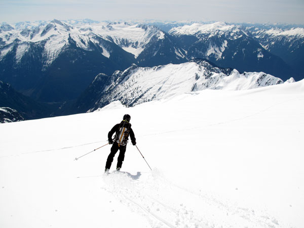
As we climbed higher there were a few brief descents, I de-skinned for one of them to score a few bonus turns:

As we continued to gain elevation we eventually popped over a roller and the summit pyramid came into view (on the right side of the photo):

At this moment two thoughts crossed my mind: the first was that the summit was still pretty far away, and the second was: holy smokes that looks steep, there is no way in heck I am going up that! The summit pyramid is a 4th class rock scramble in the summer; we had been hoping for consolidated snow that we could climb using the ice tools that we had brought and snow pickets for protection. However, the foot of fresh snow that had just fallen rendered our snow pickets useless for protection and made the climbing considerably more difficult so at this point we tacitly abandoned our goal of reaching the summit and reset our sights on getting as high as we could before enjoying the ski back down the glacier. After a short snack we continued along towards the base of the summit pyramid:

We were starting to get pretty tired by this point but we bravely soldiered on, and before too long I was standing at the base of the summit pyramid gazing up and wondering about what could have been in better snow conditions:

Before long Jeff joined me, and after it became clear that Redwood had opted to take a nap instead of ascending final few hundred feet to join us we snapped our "almost summit" photo and prepared to head down:

We then headed back down the wind packed snow to join Redwood who was just rousing himself to join in for the ski down:

The upper slopes were a bit difficult to ski as the snow had become wind-packed and alternated between being drifted up and crust. It was 10:00am by this point, and while the snow wasn't showing signs of warming at these high elevations (we had turned around at 8,600 feet, about 500 feet below the 9,147 foot summit) it almost certainly would be at the lower elevations where we had ascended on frozen crust so it was a good time to starting to head down. So, we turned tail and headed down:

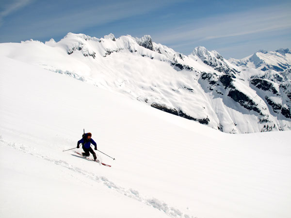
Redwood was far and away the best skier of the group, and held a clinic on how to rip awesome tele turns in the high mountains:

As always, the miracle of skis (I can't believe that anyone would even consider using snow shoes) meant that what had taken a long time to ascend was really fast and really fun on the way down, especially after we got out of the wind pack and into some really nice snow conditions. We made it through the somewhat disconcerting areas of the avalanche debris field and south-facing traverse without event, and before long we were standing back on the saddle (the guided group had left by this point) taking a group photo:

Great success! We dropped down another few hundred feet to our campsite, looking forward to pulling our thermarests out of the tent and taking a nap in the sun. However, upon reaching our tent platform we had the unpleasant surprise of not finding the corresponding tent that we had left their that morning. Our first instinct was that the guided group had stolen it, but upon reflection that we had not bothered to secure the tent to the slope in any way, we peeked over the steep edge of the ridge and managed to spot the tent a few hundred feet down the hill wedged between two trees that had thankfully arrested its progress down the mountain. Stinker! At this point we were all feeling pretty gassed, and unanimously agreed that eating sandwiches and lying in the sun for a few hours was a much better idea than retrieving the tent:

We all adopted the moderately comfortable position of lying on our backpacks with our feet on our boots and our heads resting on our helmets, and passed the time with idle conversation while eating delicious sandwiches. Eventually the sun went behind a cloud and the wind picked up so we decided the time had finally come to retrieve the tent. I volunteered to head down the slope, with the plan being to tie the rope (which we had not yet used for anything else on the trip) to the tent and have the others drag it back up. The problem with this plan is that while climbing ropes are 200 feet long, the tent was another 100 feet down the hill from the end of the rope. After a brief attempt to drag the tent (filled with all of our sleeping bags, thermarests, and Redwood's iPhone) 100 feet uphill to the rope in waist deep snow, I solicited Jeff to come down and join me. We managed to partially dismantle the tent and collectively bring everything up to the end of the rope and secure it so that Redwood could drag it up. We yelled up to Redwood to start pulling, which he did after a brief delay (he had fallen asleep while waiting for us to get the tow system set up) and before too long we were all back up on the ridge with the tent in hand.
We soon leaded everything up, donned our boots and skis, and headed back down the ridge. The ski out was pretty fun, with the snow being quite heavy and sticky but also quite enjoyable since no matter what skiing is just darn fun. We made good progress and eventually we were back in the patchy sections periodically removing our skis to scramble across creeks and other obstacles:

We finally made it back to the car, where we thankfully removed our ski boots for the last time and changed into our civilian clothes before bump-starting the VW bus and heading back to Seattle. We stopped at the Skagit Brewery in Mount Vernon for some delicious burgers and beer before continuing on to the Emerald City. What a great trip! All told we had just over 6000 feet of elevation gain:

Here is the topo that shows our route:

And finally the Google Earth view:

Good times, and hopefully not my last ski adventure of the year!