The first leg of our journey was a 10 hour overnight flight to Amsterdam, where we had a 2 hour layover before boarding the 12 hour flight that took us to Cape Town. After 1 movie, lots of reading, and some fitful sleeping we finally landed in Cape Town at 11:00pm on Friday, Nov. 12. After passing through customs we met the driver for the shuttle that we had arranged to our hotel, and just after midnight we were finally checked in to our home for the next few days. We are staying at the Hotel Protea Fire and Ice, which turned out to be quite a good hotel despite its ostentatious (or in their words, “funky”) décor. The general hotel theme is hard to describe accurately and I didn’t take any pictures, but it reminded me of a haunted house crossed with a Las Vegas casino. However, it had a great location, friendly staff and good breakfasts (my top three important factors for hotel) so it worked out well.
After a good night’s sleep we woke up the next morning at 9:30am and cracked the blinds for our first day in Africa. We were on the top floor of the hotel and had a great view of Table Mountain, though it was shrouded in cloud at this point. We headed downstairs for the hotel breakfast which was quite good, a little too good as I ended up overdosing a bit as I always do on my first day at a buffet-style breakfast. It wouldn’t have been so bad except for the two long flights the day before we had sat completely stationary and been fed every 2 hours. In any case, I spent the rest of the day feeling like a camel as I didn’t eat anything for a 10 hour stretch between breakfast and dinner whereas I usually eat every hour, on the hour. After breakfast we walked a few blocks to pick up our rental car, and then headed out on the day’s adventures.
The first mission was to find the City Rock climbing gym, so that we could pick up a guide book for the areas climbing that we hoped to sample. I had originally wanted to check out Rocklands which is a world famous bouldering area, but had dropped that in favour of some of the climbing areas closer to Cape Town for three reasons:
- Rocklands was about 220km away from Cape Town and we only had 3 full days there
- We had no crash pad
- Roanne hates bouldering
After getting used to driving on the left side of the road and going in plenty of loops through some moderately sketchy looking areas (as in North America, the climbing gym was in an area where there was cheap real estate as opposed to a more central location) we finally found the gym and picked up the guidebook. By this time it was past noon, so we decided to spend the rest of the day doing random acts of tourism since we were also still a little bleary-eyed from the recent travel marathon.
First on our list was the Kirstenbosch National Botanical Gardens, which had come highly recommended by our friend Simon who hails from South Africa. Upon arrival we found out that it was a World Heritage Site, so we were pleased to have our efforts at tourism validated. The Gardens are set on the flanks of Table Mountain, which provides a spectacular backdrop for the wide range of plants we were able to explore:

We spent a couple of hours wandering through the gardens and checking out the local flora. Some of the more notable plans were some that looked like a bird (I can’t remember their name):

As well as a wide range of Proteas which are a type of flower that our hotel was named after:

There were also a number of interesting sculptures in the park, here is Roanne taking a look at one of them:

At a few points during our walking tour I observed signs for Skeleton Gorge leading out of the park; from my reading of the Cape Town guide prior to our arrival I was pretty sure that this was one way to gain the top of Table Mountain, and as such I tried repeatedly to direct our walking tour off on this tangent (looking at plants is nice, but it becomes somewhat difficult when there is a nearby mountain that is begging to be climbed). However, each time Roanne became wise to my tricks when the wide gravel path turned into an overgrown dirt trail and my efforts were for naught. I resigned myself to postponing the foray up Table Mountain for another day or two, and we made our way back down through the gardens. One of the more notable sights that we passed on the way down was Colonel Bird’s Bath (not a bird bath owned by the Colonel, rather, a bath for Colonel Bird) which was quite old with some history attached and in a nice setting:

We also saw our first baobob tree of the trip, a specimen that had been transported from eastern Africa. Back in the car we continued on our merry way, heading south towards the eastern shores of the Cape peninsula and the Indian Ocean coast. The drive was really spectacular after reaching the coast, as we wound through a number of small fishing (and surfing) villages as we contoured down the cape heading for its southern terminus at the Cape of Good Hope. Along the way we stopped at Boulders Beach where there was a small national park that was home to a 3000-strong colony of African penguins. After paying the entry fee of 40 rand we did the short stroll along the boardwalks to the beach, along the way being forewarned about the ferocious nature of these outwardly mild-mannered sea creatures:

Here is a shot of the penguins themselves, thankfully we were able to stay out of harm’s reach during our viewing of them:

While parked at Boulders Beach we encountered for the first time the South African phenomenon of the day-glow clad parking lot attendants: every spot you can park has at least one person there who directs your parking and hangs around the lot, and while they officially have nothing to do with the parking lot, you are expected to pay them a few rand upon returning to your car. At first I thought this was a bit like extortion, but then I realized that they are performing a valuable service of keeping your car safe from would-be thieves while you are gone, so I was happy to see them and pay them for their efforts.
From Boulders Beach we continued on down the coast, and eventually reached the border to the national park that encompasses the southern end of the peninsula. We entered the park and continued south, with views of the oceans on both sides (the Atlantic and the Indian Ocean) becoming visible as the peninsula narrowed. Upon reaching the southern end we first headed to Cape Point, since the Cape of Good Hope is the southernmost point, Cape Point has light houses on it and is more visually impressive. After parking the car we headed up towards the lighthouse up on a bluff overlooking the Cape:

Here we learned that this lighthouse was no longer in service (as of the early 1900’s) since its height above the water meant that it was often obscured by cloud and mist, making it completely useless to passing ships. The lighthouse was in service for over 60 years before a decision was made to replace it with a lower one further out on the point, so apparently sailors (or lighthouse operators) are not quick learners. Just in front of the lighthouse was a sign with distances to various cities, from which we learned that we were 12,800 km from New York City, so probably about 17,000 km from Seattle. A long way from home! I guess if we had to walk back, and we could cover the distance of a marathon each day (assuming there was a bridge across the Atlantic) it would take just over 400 days. Thank goodness for air travel!

Here is a shot of Roanne and on the rocks just in from of the lighthouse, looking out over the boundary between the Atlantic and Indian Oceans:

From the lighthouse we descended further to another viewpoint overlooking the new, lower lighthouse which has been in operation since 1915 or so:

This one can be seen from 63 km away, and has a light that puts out 10,000,000 candlepower. I don’t know anything about candlepower so I have no reference point, but that sure sounds bright! On the hike back from the point we saw a small furry animal that from subsequent research we are pretty sure was a Dassie, though I didn’t get a photo of him. From further back we had a great a great view back towards the bluffs of Cape Point with the waves of the Atlantic pounding the shoals below (did I mention it was windy?). Awesome!

Back at the lighthouse, we booked it back down the hill to the car since the sun was getting ready to set and we wanted to make it to the Cape of Good Hope before it did so (and after that, perhaps more importantly, out of the park before they locked the gates at 7:30pm). It was a short drive between the two points, and on the way in we saw some ostriches patrolling the beach:

We pulled into the parking lot in time to take in the view (which wasn’t as impressive as that of Cape Point since it was lacking the steep cliffs) and snap a photo to prove that we were really there:

We lingered for a while to soak in the history and take in the setting sun:

The sun being down, we jumped back in our car (a nice little white Nissan Tiida) and gunned it for the park exit, rolling through at 7:24pm with 6 minutes to spare. The driving on this trip was quite enjoyable, driving a stick shift is fun to start with and it becomes even more interesting when you have to start driving on the other side of the road and shifting with your left hand. Exciting! Our plan had been to drive all the way up the western side of the cape back to Cape Town, but unfortunately it became dark halfway up so we aborted and headed up and over the mountain that runs down the spine of peninsula and made our way back to hotel by a shorter route. It was 9:00pm by the time we were back in our hotel room but we decided to head out and find some dinner outside of the hotel since we didn’t want to be lame on our first night in Africa.
From our Cape Town guide we found a recommended spot that was only a few blocks from our hotel called the “Royale Eatery”. It was busy and bustling which is a good sign, we had to wait a little while for a table but the time was well spent enjoying some lager and stout on the accompanying roof top bar. The establishment specialized in burgers (so we ended up being half lame, we didn’t eat at the hotel but we did end up at a burger place), but we salvaged some of our Africa credibility by ordering an ostrich burger which was actually quite good (and I didn’t feel bad since the ostriches we had seen that afternoon hadn’t seemed all that welcoming). We then headed back to our hotel for another much-needed sleep.
The next day dawned bright and sunny (though we didn’t realize immediately since we slept until 8:30am, about 3 hours after dawn) with none of the cloudy mist that had enshrouded Table Mountain the day before. We were pretty excited to sample some of the sandstone climbing to be found on the peninsula, so we loaded up our gear and drove south to the crags at Silver Mine that had been recommended by the employees at the climbing gym. We paid our small entry fee since the climbing is on a nature preserve which is part of the Table Mountain National Park, and then hiked in to the area through the scrubby bushes and succulents that carpeted the landscape:
After some confusion caused by signs talking about nesting birds we finally ended up at one of the crags, called “Blaze of Glory”. The climbing looked really good, slightly overhung with really featured rock that looked a bit like some of the stuff at Red Rocks where the rock is littered with jugs formed by the hard patina staying in place while the softer sandstone behind it wears away. Our hopes were confirmed as we started climbing, lots of amazing positive holds and really fun climbing. We did four climbs here ranging from 5.10- to 5.11-, all of them really fun. I have decided that while on vacations I like to do moderate climbs that I am relatively sure I will onsight without too much difficulty. Nobody likes having their ego crushed while on vacation; I would rather feel like a hero as I float up cruiser climbs that are well within my abilities. The temperatures were just on the border of being too hot to climb in the sun, but it was a nice change from my last international climbing trip where my fingers almost fell off while climbing in a snowstorm in Ceuse (apparently the limestone pockets there are the best in the world but I can’t pass judgement since my fingers were too numb to feel any of them).
As we climbed we chatted with some friendly South Africans who were also enjoying a day of climbing in the sun. The only hiccup at this wall as a close encounter with some potentially dangerous wildlife, as we spotted a small snake lurking near the base of the wall at the route we were on:

Roanne was crippled with fear, but after the South Africans assured her that it was neither a Black Mamba nor a Puff Adder (it was in fact a benign mole snake) I was able to coax her back onto the wall and our leisure activities continued. We had been trying to reach the Main Crag and had only ended up at Blaze of Glory by accident, so eventually we inquired with the locals as to whether or not it was worth checking out, to which they assured us that it most certainly was, with the routes there being far better than those at Blaze of Glory. This led me to silently question what the heck they were doing at Blaze of Glory if that was the case, but some questions are better left unasked so we thanked them and closed up shop to head over the Main Crag. As we headed out I took a photo of Blaze of Glory (unfortunately without us climbing in it) with the Indian Ocean in the background:

We found the main crag without too much difficulty and it was indeed much more impressive than Blaze of Glory crag, with much longer and cleaner looking lines. We started up one route only to be beaten back by a nesting starling that dive bombed us repeatedly until I gave up and downclimbed to go try a different route. The next route met with more success, and while I was climbing some other climbers arrived who happened to be the guy from the climbing gym who had sold us our guidebook accompanied by an American girl. They ended up on a climb beside us called Sterling Silver which was the next on that I had wanted to try. I was thinking it might be a long wait to get on it as he was struggling pretty hard on it (it was a 5.11a), but about halfway up the route he realized that he only had 9 of the 14 required draws for the route so he decided to lower off of a single bolt rather than back clean to get draws to finish the route. At this point I began to question how savvy he was, despite his “local” status. When he was back on terra firma, Roanne had just lowered from successfully climbing the 5.10+ that we had been on and our rope was threaded through the chains and ready to pull.
At this point the climbing gym guy (let’s call him Franz since I don’t know his name) put in a request to switch ropes with us, which I met with a baffled stare. He then explained that his female friend wanted to top rope something, and the climb that we had just done was currently the leading candidate, evidently a more attractive option than his rope which was threaded through a single bolt half way up the climb that he had been attempting. I then explained to him that due to the slightly overhung nature of the climb our rope was ready to be pulled from, with no directionals in place (since Roanne had naturally cleaned the draws on the way down) if his Amerian female companion (let’s call her Sally) fell at any point on the climb she should need to lower to ground since she would not be able to get back on. Franz seemed to grasp the meaning of my sage remarks, and declared that he would then climb it first so that there would be some directional in place for Sally, should she fall while top roping. I assented, thinking that he meant he would lead it on his rope so that Sally could follow it, with the implication that there was no longer any need to switch ropes. As I went to pull our rope I was stopped by a word of dismay from Franz, who explained that the change of course didn’t mean that we weren’t switching ropes, it just meant that HE would top rope it with no directional, so that he could install some on the way down so that Sally could then top rope it safely. Inwardly I wondered at the logic in this, since if you are sure that you won’t fall on something while top roping (as you would need to be on this route since you couldn’t get back on the route if you came off on top rope), why not just lead it? But locals know best, so I nodded my agreement and we proceeded to climb our next route using their rope while Franz navigated up the cliff on our top rope.
At this point I will abandon the story of our climbing to relate Franz’s exploits in more detail, as this will likely provide more entertainment for the gentle reader of this blog. Franz eventually made it up the 5.10+ without falling (though I was preoccupied with my own climb so I was not privy to the techniques he used to accomplish this goal), and upon lowering he decided to put in a directional for Sally. He didn’t have any quick draws on him (he had left them on the 5.11a he had been on and I was finishing for him), and while I didn’t witness him lowering I can only surmise that he had one sling with one locking carabiner. In this situation, most reasonable climbers would choose to girth hitch the sling through a bolt and clip the locker over the rope as the directional. Franz however, is not like most reasonable climbers, and he chose to do things a little differently by clipping the locker through the bolt, and girth hitching the sling around the rope (for all intents and purposes a prusik knot). Upon reaching the ground, Sally tied in and got ready to climb, but much to his dismay he found himself unable to take in the rope to belay Sally since (as one might expect) the prusik knot formed by the girth hitched sling prevented this. Luckily he was still able to pull the rope in the other direction to retrieve it, which he did. The next step for Franz was now to lead the route, in order to get the top rope set up properly and to retrieve his sling. However, at this point Franz realized that his 9 draws were insufficient to complete this route (as they had been insufficient to complete the last route that he had tried). I briefly thought about offering him our draws, but then we would have had to wait to start our climb until Franz finished, and I quickly came to the conclusion that I didn’t spend 24 hours on a plane for my one climbing day in Cape Town to be spent bailing out the locals. So, I advised Franz that he should lead it and back clean draws as necessary to finish the route. Franz then proceeded to lead the route and get the top rope set up properly and then lowered off, only for Sally to decide that she didn’t want to top rope the route after all, so they packed it in and went home. Not a great day out at the crag for our South African friend, hopefully he wasn’t counting on impressing Sally with his climbing prowess!
Anyways, Roanne and I did a few more routes and then packed it in also, as we had to be out of the park by 7:00pm when it closed. There was still about an hour of daylight left, so we decided to head across to the west side of the peninsula and complete the drive up the coast that we had started the day before but then aborted when we ran out of daylight. The drive was amazing, along a narrow, winding road that clung to the edge of the cliff with rocky cliffs dropping steeply down to the pounding surf below. We stopped at a pullout for some views and a photo, from our hair you can see that it was really windy:

Here is another shot from that viewpoint, looking back along the way we had just come:

Upon exiting this stretch of highway we had to pay a small toll, but it was definitely worth it for the impressive scenery. By this point the sun was getting pretty low in the sky, so we decided to stop for a picnic dinner at the next point where we could get down to the water. Eventually the road descended down towards the water, and we stopped at a pullout and hiked down to the water where we enjoyed our picnic of ciabatta bread with tomatoes and cheese (we had picked it up that morning in the Pick and Pay grocery store). Here I am handing over a delicious sandwich to Roanne:

After enjoying our sandwiches we lounged on the rocks as the sun dropped below the horizon, witnessing a nice sunset over the Atlantic Ocean:

We then continued on our way back to the hotel, where we lounged for bit before turning in for an early night’s sleep. The next morning I tried my best to convince Roanne that we should go climbing again, however she was pretty set on climbing Table Mountain and logging some beach time so that was the plan. We enjoyed another delicious hotel breakfast and then headed out, with the first item on the agenda being a visit to a local establishment called “Charly’s Bakery” which is known for its delicious cupcakes. We followed the directions in our guidebook and quickly arrived at our destination, here is Roanne approaching the specified address, you can see that their sign is fringed in some lovely barbed wire:

Unfortunately we were unable to find the bakery itself, and after asking some bystanders we were informed that it had recently moved to a new location a few blocks away. We headed to the new location and were happy to find a more welcoming looking sign and building, however, we were unhappy to find out that it was closed for the day, only being open from Tuesday to Friday (today was a Monday). Stinker! No chocolate cupcakes for a morning snack. We shelved our disappointment and continued on our journey, headed for the lower cable car station at Table Mountain. From reading the book we were given the impression that there were multiple ways to climb Table Mountain, but we were unable to find any good information on which one was best or on how easy it was to get lost on the various routes, etc., so we decided to go for what seemed to be the default option, the Platteklip Gorge for which the trailhead was close to the cable car station (you can also take a cable car to the top if you don’t want to hike). As we drove up the mountain towards the station we were shepherded into a parking spot by the road by one of the ubiquitous day-glow clad parking attendants, who after directing us into the spot handed us a slip informing us that his name was “Desire” and he would be looking after our car for the day.
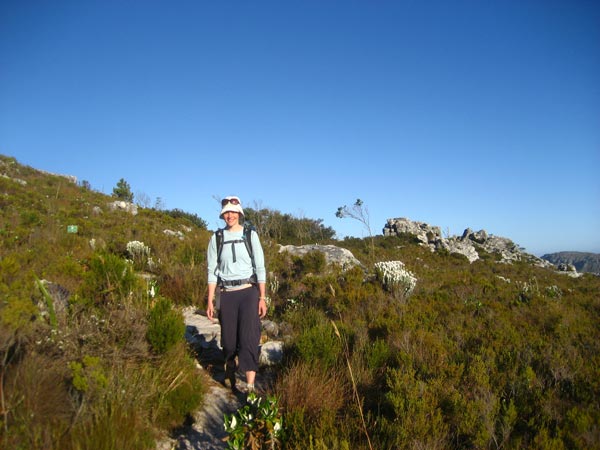
We then continued on foot to the cable car station, where we found out that the Platteklip Gorge trailhead is actually a few km past the cable station (on a paved road) with plenty of closer parking spots. We felt a little bit like Desire had played a dirty trick on us and added several km to our hike, but it was a nice day (albeit a bit hot) so we weren’t too bothered. We easily found the trailhead and started up, with the hiking being reminiscent of a hot African version of the Grouse Grind (steep with lots of steps). The Platteklip Gorge is a cut in the plateau that forms the top of Table Mountain, as we climbed higher it became evident where we were heading:

The trail went up open slopes but it was very well constructed out of rocks and with good views, so despite it being a bit hot it was a nice hike. Here I am headed up:

On other thing we noticed was that the South Africans have developed very effective methods for discouraging hikers from cutting switchbacks; note the trailside barbed wire in the photo below with Roanne steering well clear of it:

Here is another shot of Roanne ascending, with the great view back down to Capetown and the Atlantic Ocean in the background:

We reached the top after just over an hour of hiking, and were rewarded by a nice cool breeze wafting along the plateau. From the top of the Platteklip Gorge we headed south to the true summit of the formation which is located at Maclear’s Beacon. Here we were rewarded with good views, and spent some time lounging in the sun and identifying the various mountains and bays that were visible. We then headed back north to the upper cable car station which was thronging with tourists who would have struggled on the hike to the top but had no problems on the cable car ascent. Despite the relative crowds there were some good views down to Cape Town, here is one with the Lion’s Head on the left, Signal Hill in the center (also known by the less appealing name of the Lion’s Rump), and behind that Robben Island. Robben Island is similar to Alcatraz near San Francisco in that it was a penitentiary on an island close to a large city; it is no longer in use but it is where Nelson Mandela spent many of his 27 years of wrongful imprisonment.

We decided to take a cable car down as we had already seen the trail on the way up, and this would give us some more beach time before our planned evening ascent of the Lion’s Head. The cable car was pretty unique in that the interior revolves as it descended, so by the time it reached the base we had seen all of the views on offer. After thanking Desire for guarding our car and making a donation for his services, we headed towards Camp’s Bay which we had targeted for the afternoon’s beach activities. We headed to Clifton Beach, where we were rewarded with white sand and nice views. We set up shop on the beach for a few hours and whiled away the time reading in the shade and playing in the surf.

Just before 6:00pm we left the beach to head back up to the saddle between Table Mountain and Lion’s Head, where we parked and began the hike up Lion’s Head. This is a much shorter hike than Table Mountain, but it is a smaller summit and enjoys good views of the city, Table Mountain, and the sunset. Here is a shot of Table Mountain taken as we began our ascent:

The trail spiraled around the formation as it wound its way up, finishing with a few steel ladders to assist hikers over the final steep and rocky sections. We reached the summit with about 30 minutes to spare before sunset so we drank the last of our water and lounged on the rocks waiting for the sun to set:

When the sun did finally set it was well worth the effort for the hike up:

We then headed back down, stopping to smell some of the nice flowers along the way:

As we continued our descent it became pretty dark and we had good views of Cape Town as its city lights began twinkling into view:

We headed back to the hotel where we spent some time on a foray into Cape Town to find an African restaurant recommended in our guidebook only to find that it had since closed down (I guess it couldn’t have been that good). As it was getting a bit late at this point, when we didn’t find any suitable replacements nearby we decided to abort the mission and headed back to the hotel where we ate some good African food in the hotel restaurant. We then headed to bed as we had a 6am start the next morning to catch our Air Madagascar flight to Nosy Be.

No comments:
Post a Comment