Monday, August 30, 2010

Paris

The project I am working on at my place of employment is being carried out in conjunction with a few other companies who are based in Europe, which means that every 6 weeks or so we have in-person check-in meetings held in Europe, usually in Barcelona though the next one is in Belgium (stay tuned to this blog for live coverage of Belgian World Cup Cyclocross races, coming in October). A work trip to Europe means one thing to me: side trips. It would be out of the question to have someone else pay for your flight to Europe and then fail to take advantage of it by tacking on weekend trips before, after, or during the business part of the trip (which is really just a side show to all the fun that is waiting to be had). Preferably these extra trips should be to mountainous regions of Europe (the Alps are ideal), and should generally avoid museums, old churches, and other such trappings of “culture”. Actually, up to one church (no more than 30 minutes spent inside) and one museum (no more than one hour spent inside) is permitted per trip under my leisure-planning regulations.

The last trip of this nature to Milan/Barcelona took me into the Italian Dolomites for some climbing and cycling and then into the French Pyrenees to see a stage of the Tour de France (see previous blog entries). The business part of this trip took place on a Monday to a Thursday, so the plan was to fly to Paris on the Friday of the week prior, spend the weekend in Paris, then on to Barcelona to fulfill my obligations, then on Friday morning fly to Geneva and take a bus to Chamonix to spend a few days before returning to Seattle on Tuesday morning. Luckily Roanne was able to join me, she has a number of relatives in the UK so while I was in Barcelona working for the man, she went to the UK to hang out with her family and do a bit of work remotely. Roanne can sometimes exhibit a tendency to try and skew the agenda away from my preferred itinerary of all-day mountain sports and towards museums, old churches, and shopping, but luckily we were able to come to an understanding leading up to the trip and plan something that we were both excited about.

We flew out from Seattle on Friday afternoon on a direct flight to Paris, and after an uneventful flight we landed in Charles DeGaul airport at 8:30am on Saturday morning. After clearing customs where the customs agent just stamped our passports and didn’t say a word to us (EU customs are so much smoother than North American ones!), we hopped on a train and after one transfer we found ourselves at the Gare de Lyon train station, which to my understanding was quite close to our hotel. After walking through the cavernous Gare de Lyon train station a few times we finally oriented ourselves and headed out onto the streets towards our hotel. The hotel turned out to be quite a bit further than we thought so it was a bit of a hike, and in retrospect we should have taken the metro, but it was a nice walk just the same and it was fun to see all the everyday parts of Paris that we like so much:

The hotel we were staying at was called the Sport Hotel; I have always seen similarly named hotels in Europe (generally in the Alps) and they sound really fun which is why I had booked this one. However, this hotel turned out to be sporting in name only, as there was nothing different about it compared to any other hotel I have stayed in (other than that the rooms were quite small and the proprietor seemed hesitant to give me an extra pillow). After a short nap to recover from the flight, we headed out onto the streets were we stopped for an espresso and a sandwich at a street side café, and then tried to check out bikes from the city-wide bike share system:

Unfortunately this was my 3rd unsuccessful attempt to access a city wide bike sharing system in a European city (after similarly unfruitful attempts in Milan and Barcelona), this time it wouldn’t accept our credit or debit cards for the deposit. Maybe if they ever bring bike sharing systems to North America (unlikely, as the extra bikes on the road might slow down all of the single-occupant SUVs. On a related tangent, I read that a small town in Colorado recently banned bikes from riding on their roads. USA! USA! USA!), I will have better luck with accessing the bikes by virtue of being a local. Anyway, with our preferred method of transit off the table, we resorted to our second choice and headed for the metro. Our first foray took us east to the outskirts of Paris where we walked though a large park and made our way to the Jacques Anquetil Velodrome where they had held the cycling events in one of the first Olympic Games (or something like that, please don’t quote me). I had been picturing something like the Marymoor Velodrome which was open so that you could walk around and look at it, but this sporting complex was considerably more elaborate and unfortunately involved locked gates that denied us access:

Oh well, at least we tried from here we boarded the metro again and headed into the heart of Paris, disembarking near the Cathedral de Notre Dame and bunch of other historic sites. Roanne and I had visited many of these spots during a trip to France that we took back in 2002, but they were just as impressive so it was fun to see them again and walk along the Seine with the other holiday makers. Roanne was evidently still feeling sleepy after her nap, this is the pose that I found her in after returning from one of the rare public bathroom facilities in Europe:

After rousing Roanne from her slumbers we admired the Notre Dame for a while before continuing on our way:

We then continued our tour, walking along some streets and seeing some stuff as we headed to a confectioner that had been recommended by a friend of Roanne’s. We eventually found the store, and they specialized in these things called macarons (which I at first thought were the same as macaroons, those unappealing blobs of coconut; thankfully they are not). Macarons are light and puffy blobs of flavoured sugar, and while they are pretty good, I have definitely had better sweet delights (Top Pot donuts are one example). Here is Roanne standing outside our macaron vendor of choice:

We then headed to a kebab restaurant that had been recommended for dinner, unfortunately the one we had planned on eating at was closed (like most of France, they apparently take all of August off) but we found another one nearby and had a really good dinner before boarding the metro and heading back our hotel.

The next morning dawned with cool weather but mostly clear skies and sunshine, so with our day of acclimatization/culture under our belts, we decided to head to Fontainebleau to try and track down some bouldering. For any non-climbers who might be reading this, Fontainebleau is a famous bouldering area located about 50km from Paris. It is a really unique style of sandstone, and it’s proximity to Paris coupled with the flat, sandy landings and plethora of boulders mean that people have been climbing there for many years and many classic problems and benchmarks have been established there. I had seen it in a lot of magazines and videos so I was pretty excited to check it out, even though I didn’t have a crash pad with me (we did have our climbing shoes and chalk bags).

Upon leaving our hotel we found that a street market had been set up directly outside, so we spent a while browsing the market, buying some fruit, and complimenting the vendors on their delicious looking tarts.

We then rode the metro to the Gare de Lyon train station, where we got confused and wandered around a bit before a really nice old man approached us and asked if we wanted to go to Fontainebleau (he must have guessed we were climbers by our appearance, since we hadn’t said anything to him), and guided us in person to the correct platform and told us which train to take. Who says the French aren’t friendly or helpful?

After arriving in Font we took a bus into the middle of the town where we inquired at the information center as to where we could find some bouldering. Fontainebleau was actually a bit different than I had pictured it, for some reason I had assumed we would be able to just take a train there, disembark, and then walk in any direction and encounter large quantities of amazing boulder problems. However, it turns out that this is not the case, while the town is relatively compact, the forest of Fontainebleau is really large, and the bouldering areas are pretty spread out with a car being required to access most of them. I guess in this case a little advance planning/research would have been appropriate, but hindsight is 20/20 and who would have ever guessed that? Luckily there was one area that was only about 15 km away so that we could ride bikes to it, and there was even a special trail (called FB since it went from Fontainebleau to some other town that started with a B) that would take us there.

We headed over to the local bike shop where we were able to pick up a couple of low end mountain bikes that would serve as our trusty steeds for the day. Before leaving town we picked up a baguette and some hummus at an outdoor market that we encountered, and then headed out to try and find the FB trail using our somewhat inadequate map. After about 10 minutes we found ourselves on a really busy road that didn’t seem to match any of the roads on our map, much less the vaunted FB trail, so stopped at some sort of fair where we asked some people in one of the booths for directions. They sent us back where we came, and eventually we picked up the FB trail which is marked by small, often worn off and unrecognizable, painted white letters on the pavement. How silly of us to be on the lookout for signs instead of white splotches on the pavement! Here is Roanne established on the FB trail and eager to get underway:

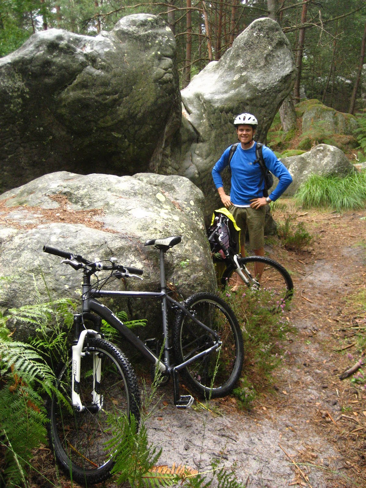
Now happily on course, we guided our bikes (which, incidentally, were branded “rock dasher” or something similarly indicative of our quest for the boulders of Font) along the FB trail which was a mixture of paved paths, dirt roads, and trails. We eventually arrived at our destination, called the Gorges du Something-or-other, and happily began scanning our surroundings for boulders. We soon realized that, as the name implied, the boulders were likely stored down in the gorge that was in front of us, so we headed down a long flight of wooden steps to gain access to the bottom of the gorge. Unfortunately at this time it began to rain, but we continued our hunt. After roaming around some sandy trails on the bottom of the gorge (again, some sort of advance planning in the form of a guidebook would have been eminently useful), we eventually found some boulders that looked climbable, here I am proudly posed in front of our find:

By this time it had started to rain pretty hard, so we took shelter underneath some trees and snacked on our baguette and hummus, which was really delicious. Here is Roanne about to dig in to our lunch-in-the-woods:

You can see that Roanne maintains her sunny disposition even during most of the semi-ridiculous adventures that I drag her on (“most” is a key word in this statement, there are exceptions). For some reason we didn’t see any other tourists doing a rainy hike-a-bike through the woods of Fontainebleau in search of large rocks, how strange! At this point Roanne decided to read her book (actually, her kindle, which was acquired during our technology revolution last year) while I went off in search of more boulders. I did find a bunch, legitimate ones that had the coloured dots and circuit directions painted on to them (which Fontainebleau is known for), so that was fun to see, but by this time they were way to wet to climb and it was still drizzling so after a bit of scrambling to allow a checkmark in the box beside “climbed at Fontainebleau”, I threw in the towel and we headed back towards the stairs up out of the gorge. Here we are at the conclusion of our Fontainebleau boulder quest, with some evidence of our success on the hill side in the background:

We headed up the stairs past some French families who were descending and complemented our bike-carrying endeavors with “Bon courage!”, and were soon on the FB route back towards F. We decided to forego B since there was a large chateau in Fontainebleau that we were interested in checking out and which could easily fill the remainder of the afternoon that was opened up by getting rained out at the boulders.

After returning the bikes we walked over to the Chateau Fontainebleau and did a tour through the grounds, with the first thing we happened upon being a sculpture of peeing dogs:

We continued our tour through the grounds of Chateau Fontainbleau, which was quite large and impressive. The front of the Chateau features the "Farewell Courtyard", which is where Napolean bid his friends farewell before being exiled to the island of Corsica:

There was a small lake/pond on the grounds near a cafe, where we stopped for espresso and tea and sat and observed people rowing around the lake on boats that could be rented out. There was one group in particular who was particularly entertaining to watch, it was a man and woman with their young daughter, and they were attempting to navigate the lake with just a single oar. They were having fairly limited success, slowly turning in circles as the wind below them to one side of the water. Bystanders were offering them tips such as "It works better with two oars", and general words of encouragement.

I'm not sure how they got out there with just one oar, but eventually the apparent proprietor of the boat rental business, a teenage girl, rowed out to help them. She was also rowing incorrectly, facing forward in her boat and using the push for her "power" stroke (the power descriptor is used very loosely here). Nevertheless, she finally made it out to them, at which point she realized that she should have brought an extra oar to give them, since if the gave them one of hers she would be in the same situation they were presently in. So after a brief discussion with them, she headed back to shore and returned with another oar to give them. At this point we had had our fill of this drama unfolding on the high seas, so we continued on our walk without ever finding out if they eventually made it back to shore or had to be rescued by the french navy.

Our walk next took us through some more courtyards and into some gardens, the nicest of which was the "French Garden" which had a good view back at the Chateau that gave an idea of how expansive it was:

Eventually we decided to head back to the train station and make our way back to Paris. We ended up walking all the way back to train station as the buses didn't seem to be running too frequently, and then rode the train back to gay Paris without incident. Upon returning to our hotel room Roanne took a nap while I went for a short run on a nice elevated walkway that I found (I think it was a converted railroad, they have something similar in New York City) and then we went out for a late dinner where we enjoyed pizza and a small vat of wine that Roanne ordered. The next morning came bright and early as I had to catch a 7:30am flight to Barcelona for the work part of the trip, and Roanne headed over to the UK to visit her relatives there.

Tuesday, August 17, 2010

Mount Alpha

In August my brother Trev was visiting my other brother Fras in Vancouver for a week, so I headed up on Friday morning to join in on some weekend adventures. On Friday afternoon we headed up to Squamish where we checked out a newish bouldering area called The Hatchery which was pretty fun although whatever meager bouldering strength that I had at the start of the season has now completely dissipated as I have focused on sport climbing throughout the summer. The term “focused” is used very loosely as it means getting spanked out at Little Si once a week (though I did end up sending Psychosomatic, a 5.12d that I had been trying there, which at least partially preserved my self-perception as an adequate climber). On the way back from Squamish we stopped off for some swimming at lighthouse point which was really fun, as it was a hot and sunny day.

On Saturday we headed up to Whistler for some downhill mountain bike action in the bike park, which was quite entertaining. I had never been there before but had been meaning to try it out for a while, so it was nice to finally make it there. Trev and I both rented downhill rigs which is pretty expensive ($100 and up per day), but necessary as the trails wouldn’t be that fun on a cross country bike. The bike rental along with the lift ticket ($60) make for a pricey day of mountain biking, but it is a pretty cool experience. We rode for most of the day, stopping in the late afternoon due to general fatigue and blisters.

Crankworks happened to be that same weekend, so we spent the evening watching the slope style competition where brave young men rode their bikes off of some crazy stuff in the pursuit of victory. And I mean really crazy, the biggest feature was a step up jump onto a platform where they had to go 12 feet up and 12 feet across to clear a gap and make it onto the platform, they then they launched off of the end and had to go 25 feet across and 30 feet down to clear the next gap and land back on terra firma. You might have thought it would be enough just to survive this, but the top riders were spinning 360s and doing tail whips as they hurtled off of the platform. Not surprisingly there was a pretty high rate of attrition among the riders, with several having their hopes of victory scuttled by trips to the hospital for x-rays on the various body parts they had bruised or broken when they cased it into the dirt after missing a landing.

Perhaps the most revealing moment in the competition for me was on the last run of the day: the riders had taken three runs each with the single best run determining the winner, so when the final rider took his last run, he already knew he had won based on his previous runs. As he took his place on the starting ramp for the final run of the competition, I thought “Sweet, he’ll probably do a hard-charging, all-out victory run and really have some fun and put on a show”. However, what he did do was essentially ride straight down the hill in between all of the jumps to the finish, only hitting a few of the smaller ones. I can’t say I blame him as there is no way that I would ride any of that stuff, but it did reveal that riding these features isn’t necessarily all that fun for these guys, this is their job to do this and they are just trying to survive it and hopefully bring home a paycheck.

With our bike park adventure complete, we climbed into Fras’s car and headed south back to Squamish where we camped that night on the spit and rested up for the main event of the weekend: an ascent of Mount Alpha in the Tantalus Range. The Tantalus Range lies between Squamish and Whistler just west of the Squamish River, and is composed of four striking peaks: Alpha, Serratus, Dionne, and Tantalus. Anyone who has driven to Whistler in clear conditions and is not legally blind will have noticed these majestic peaks, it has been on my list for a long time to climb one of them so I was happy to be finally doing it. We had selected Mount Alpha as our target since it is the highest (or maybe it is just the easiest to access, one or the other), and we were climbing the standard route up it which is graded 5.8 due to a couple of pitches of technical rock climbing on the route though it is primarily hiking up snowfields and scrambling up third class rock. The biggest challenge in climbing in the Tantalus range comes in the approach, which involves crossing the Squamish River followed by an arduous hike up to Lake Lovelywater.

We planned to do the climb over the course of 2 days, with the first day spent crossing the river and then hiking up to Lake Lovelywater and the second day spent climbing Mount Alpha, descending, and then hiking back out and crossing the river back to our car. We had purchased our food for the trip the night before at Sav-On foods in Squamish, so on Sunday morning we woke up around 7:00am, organized our gear, and drove north of Squamish to the turn-off for the Squamish River crossing. There are 4 standard ways to cross the river: you can charter a jet boat from Squamish to drive up the river and deposit you on the other side (or I guess if you had your own boat you could use that) which costs $50/person, you can charter a helicopter or float plane to cross the river and deposit you at Lake Lovelywater (avoiding the 3000 vertical foot grunt of an approach) which costs $Lots/person, you can use the fixed steel cables that are used by government personnel for conducting water surveys on the other side of the river, or you could swim across. The last option is not recommended since the river is about 100m across and moves pretty fast, so by they time you made it across the water you might find yourself in a pulp and paper mill south of Squamish. The first two options were ruled out because they compromised our sense of fair play as climbers and didn’t seem very sporting (they also ran counter to the most defining characteristic of climbers: being too cheap to pay for anything). So that left us with the third option: crossing the fixed steel cables.

To access the cable river crossing you drive north of Squamish and then turn off the main roads onto a dirt road on which you pass through some first nations land and on to the river. At the entry point to the dirt road we found a large steel gate, but luckily it was unlocked so we opened it up and proceeded on down the dirt road to park at the river. The steel cables are used for a manual cable car that can be winched across the river; unfortunately this cable car is kept locked up, so unless you have a key you are forced to either do a tyrolean traverse where you hook a fat steel carabiner onto the lower cable and drag yourself across, or you can do a sort of tight-rope crossing where you walk along the lower cable while holding on to the upper cable. The latter approach is complicated by the presence of large airplane warning cones on the upper cable that must be bypassed with a certain degree of awkwardness. We were forced into the latter approach by not having any carabiners large enough to fit on the thick, lower cable.

After unpacking our gear and suiting up we were ready, so we climbed the tower to the cables and off we went. A 25 foot tall steel tower accessed the cables, and Fras headed off first with Trev and I observing and offering moral support. We each had a heavy pack full of camping gear, climbing gear, and food and water, and Fras was wearing his pack which appeared to make the traverse quite difficult. The upper cable that you held with your hands was much thinner than the lower cable upon which you were walking and they were not fixed to each other in any way and so were free to move relative to one another, which meant that it took a lot of balance and core tension to stay upright and keep the lower cable beneath you. We wore harnesses and were clipped in to the thin upper cable, but if you were to fall off and dangle from your harness then I’m not sure how you regain your place on the cables, so while you would not end up in the river, you would be stranded and therefore falling was not really an option. Add this to the fact that there were 5 large airplane markers on the upper cable that had to be bypassed, the first of which was an especially awkward large sphere (which, come to think of it, is likely there to discourage people from exactly what we were doing), and you have a pretty exciting and tense 30 minutes spent working your way across the cables above the water.

Fras eventually made it across, but from the short grunts that he used to reply to the accolades that Trev and I offered him during his crossing, we ascertained two things: this was quite challenging, and it was better not to wear a heavy pack. Trev and I decided to rig up a system by which we could hang our packs form the lower cable and drag them along with us, luckily there was a thick piece of rope someone had left on the platform that we were able to use for this. We finally finished rigging our system up and headed across. It was a little spooky with the cables swaying so much over such a wide expanse of water, but the absence of heavy packs on our backs definitely made it easier going than it had appeared to be for Fras. Here is a picture from Fras’s perspective as we made our way across, about to pass the final airplane marker:


We finally reached the other side at 10:30am, the crossing had taken us about 1.5 hours in total which wasn’t too bad given that there were 3 of us and we had spent a fair bit of time figuring out the best approach and trying to rig our pack system.

Safely and happily on the other side, we removed our harnesses and started the arduous trek up to Lake Lovelywater. The distance of this hike isn’t too great, but it ascends a few thousand vertical feet, so it is quite strenuous. After about an hour we stopped for a break at a dry river bed where we refueled and inspected our food supplies for the next 2 days:


That’s right, trail mix and candy. In doing our food shopping late the night before we had spent a disproportionate amount of time in the bulk section, so we had ended up with generous amounts of trail mix (2 different kinds), peanut M&Ms, yogurt-covered raisins, fuzzy peach slices, and gummy worms. It might not be straight out of the Sierra Club’s hiker’s handbook, but it was food and it had certainly seemed like a good idea at 10:30pm the night before! We continued the approach and kept gaining altitude on the steep trail, with just some short level sections such as this one where we passed through a grove of attractive ferns:


As we soldiered on, we eventually found ourselves traveling parallel to a larger river which from our GPS map seemed to be draining down from Lake Lovelywater. It had a number of nice water falls that coursed through the trees:


While the scenery certainly left nothing to be desired, one thing that was not to our liking was the large number of bugs. Every time we stopped we were swarmed by clouds of brown flies; they didn’t seem to bite too much and were pretty easy to kill but there were so many of them that we quickly gave up on this approach and just tried to keep moving as fast as we could. We had read about the bugs being really bad up at Lake Lovelywater, but despite this we assured ourselves that the situation would be better up at the lake. It was also pretty warm, and at the frequent spots where the trail crossed a small tributary draining into the larger river we would stick our heads in the river and don “ice helmets”, with the technique demonstrated by Fras in the photo below:


After a few more hours we finally reached popped out of the gully and onto a flat area, and after a few hundred more meters we found ourselves crossing the river for a final time on a suspension bridge:


And admiring a beautiful view of Lake Lovelywater with glaciers and mountains as a backdrop:


Awesome! The bugs were no better, but we were happy to be at our destination nonetheless.

The Alpine Club of Canada maintains a hut at the lake were you can choose to stay if you pay a fee and reserve it in advance, but we had decided to forgo this comfortable accommodation since anyone who had flown up to the lake in a float plane or helicopter would likely also be staying at the hut, and we didn’t want to risk catching their “softness”. The hut did look nice though, here is a photo of it:


As we marched past the hut to the established camping area, several of its weekend inhabitants issued forth on their way to the helicopter pad for their ride back to civilization and the comfort of their SUVs, each hefting their weekend supplies in one or two large green garbage bags. Yep, I think we made the right decision to camp. We set up our tent on one of the well-built wooden tent platforms overlooking the lake, and after a brief respite from the bugs (inside the tent), we ate some candy and then headed down to the water for a swim. The water was really cold but tolerable for a few minutes, and it was really warm in the sun so it felt awesome to feel your skin slowly heat up after you climbed out of the water and onto the rocks surrounding the lake. By this time the thump-thump-thump of the helicopter carrying away the last of the outdoorsmen who had been staying at the hut had died down, so there was nobody else around and it was really peaceful.

We had a few hours before the sun would go down, so we decided to go out for a row in one of the boats that is kept at the lake by the Alpine Club. Luckily the bugs were not bad out on the water, so we launched the boat, grabbed the oars, and made our way to the opposite end of the lake.


There were a number of glaciers that descended right to the water of the lake, so it had quite a rugged and remote feel and was really impressive with the mountains rising up directly from the back of the lake.


There was an open talus field at the far end of the lake with a lot of flowers and glacier-fed streams scattered though it, so we beached the boat there and traipsed through the alpine surroundings for a while before getting in the boat to head back to our camp as the sun started to set:


We hadn’t brought a stove with us, so dinner was served cold as a mix of flax buns, cheese, and mini-peps (some sort of meat stick that Fras convinced us to buy but which actually tasted pretty good). After dinner we set about hanging the rest of our food to keep it away from the local fauna, with the most choice hanging location we could find being the flagpole on the Alpine Club hut. So, with the rest of our mini-peps blowing in the wind alongside the emblem of the true north strong and free, we squeezed into Fras’s 3-man tent and drifted off to sleep, with visions of the next day’s adventures on Mount Alpha dancing in our heads:


We woke up to our alarm at 6:30am the next morning, we knew it would be a long day so we wanted to get an early start (but not before the sun was up, let’s not get too crazy). We ate some delicious lemon poppyseed muffins for breakfast (thank you, Sav-On bakery!), hoisted our packs onto our backs, and headed up the trail for the ridge of Mount Alpha that we would ascend. The trail was fairly easy to find, but soon became fairly indistinct so that we were relying on finding the pieces of flagging that had been affixed to tree branches. We did manage to stay mostly on course though, and after an hour or so of light-duty bushwhacking we popped out onto a ridge in alpine terrain:


We progressed up this rocky ridge and it eventually turned into a snowfield, so we took out our ice axes and continued on up the snow. We had decided not to bring crampons since the information we had read on the route indicated that the snow was not too steep. Kicking steps did prove to be adequate, and unencumbered by a rope we were able to move pretty fast. Here is the view looking up the snowfields towards our destination:


We progressed up the ridge, with a few trickier sections where we had to transition from snow back on to rock, but overall the route finding was straightforward and did not present any problems. The sun was slowly climbing higher in the sky and the scenery was spectacular, here is a view looking back down the ridge to Trev with Whistler and coast mountains in the background:


Eventually we made it to the end of the snowfields and onto a rocky shoulder where the technical rock climbing started, a short pitch of 5.8 crack climbing. We changed into our climbing shoes and donned our harnesses, and Fras belayed me as I led up the pitch. The climbing was straightforward and well-protected so we quickly dispatched with the difficulties, after which Fras led a short pitch of low fifth class. Here is a shot of Trev making his way up the second pitch:


After regrouping we had some lunch and then continued scrambling towards the top. Near the top we ran into one more short pitch of low fifth class, and then it was more easy ground to the summit. Here is a shot of Fras coming up the final stretch to the summit with the waters of Lake Lovelywater sparkling in the background:


We finally crested the final series of ledges and we were on the summit! It was perfect weather and the views were spectacular, we took a few moments to eat something, admire the view, and take some photos before getting ready to head down:


Great success! We had decided to take the standard descent route of heading down the west ridge; some parties head back down they way they came which eliminates some route-finding challenges, but I prefer covering new ground on the descent to keep it interesting. The descent proved straightforward initially, as we scrambled down some rocky slabs with a lot of loose rock to gain a saddle below. At the saddle we had good views of another large glacier to the north on the slopes of Tantalus and Dionne.


From here we continued our descent heading south, with one long rappel to gain a snow field which we then glissaded down to gain some nice heather slopes. We had all run out of water by this point, so we were really happy to have the chance to drink directly from the cool streams that were coursing through the open fields of heather, grass, and wildflowers. We refilled our water bottles and continued down, marveling at the alpine paradise we were lucky enough to be passing through:


Mount Alpha does have the curse of being pretty inaccessible (unless you want to shell out for a helicopter ride to Lake Lovelywater, but most of those people probably won’t find themselves on the slopes of Mount Alpha), but this is simultaneously a blessing as it means that the setting is almost completely untouched by humans. Aside from the faint trail we were trying to follow there was no other trace of anyone having been there, and we didn’t encounter anyone else during our climb. We continued down, eventually getting to a point where we could see Lambda Lake below us, from where we knew a trail started that would take us back to Lake Lovelywater. By this time it was getting fairly late and I was pretty sure we were going to be doing part of our return journey in the dark, the only question was how much.

We had read some warnings about encountering cliffs on the way to Lake Lambda but we were not quite sure which way to go, and after encountering a steep drop when we tried to approach the lake from the west, we decided to try our luck approaching the lake from the north. We down climbed a stream for a while to gain a saddle, then crossed some snowfields, then some bushwhacking through ferns and thorn bushes, over some talus fields, and into another drainage that appeared to descend down to Lake Lambda, the only question was how much down climbing of slippery rocks would be involved. By this time we were 100% certain that we were no longer on the recommended descent route, but we were all-in so we forged ahead. After a few short down climbs and butt slides down slippery, algae-covered rocks, we were relieved to emerge onto the shores of Lake Lambda.

The tricky bit here was that we were on the wrong shore, we could look across the lake and see some flagging indicating the start of the trail that would take us back to Lake Lovelywater, but it would have been a tedious bushwhack along one shore to get there and the other shore was ringed by cliffs that would not allow us to get through. The obvious solution was to cross the lake, which luckily was only about chest deep, so we removed our packs and shoes, hoisted them over our heads, and waded on through the lake. Here is a shot of Fras heading for the opposite shore


The bottom was pretty soft and swampy which made the going a bit difficult, but eventually we found ourselves on the other side at the trail marker. Trev had pretty bad blisters by this point which had stung a lot on the water crossing, so he elected to leave his shoes off and do the rest of the descent to Lake Lovelywater barefoot, like a real woodsman. We continued on down, and by 6:00pm or so we found ourselves back at our camp which we quickly disassembled in preparation for the hike down from Lake Lovelywater. We were definitely behind schedule but the waters of Lake Lovelywater were just too inviting, so we hopped in the lake for one last refreshing dip before drying off and heading down the trail towards the Squamish River. The hike down was definitely easier than coming up, but we were all quite tired by this point so it was still tough going. Dusk was falling as we came into view of the river, so by the time we made it to the cable crossing it was completely dark and we had to deploy our headlamps. This time we went one at a time with me going first and dragging all of our packs behind me on the lower cable (a bit of a grunt), followed by Trev and lastly Fras.

It was 10:00pm by the time we were all standing safely on the east shore of the river, at which point we remembered to send text messages to Carla and Roanne to let them know we were getting down a bit later than planned (actually there had been no plan, which is probably why we were getting down so late). At this point we thought we were done, so we celebrated with high 5s and drove out the dirt road. We stopped at the closed yellow steel gate and I offered to get out and open it, but open attempting to do so, I realized that it was locked… stinker! There was a number on the gate to call if it was locked so that someone can come open it (which makes me wonder why they don’t just leave it open in the first place), but there was no answer when we tried to call that, so we sat quietly on the dirt road in the darkness and mulled over our options. Fras had seemed quite concerned about bottoming out his car on the drive down the dirt road the previous day, so I was pretty surprised when he tabled the following plan: there were a bunch of logs and rocks lying in the field beside the road, so we could use these to try and assemble a makeshift platform that we could drive the car over to bypass the gate while avoiding the ditch that ran along the road on both sides.

I was a little dubious but the others were committed and Trev is really good at building things, so at 10:30pm we went to work and by 11:00pm we had a passable log platform that looked like it might hold the weight of a Toyota Matrix. With Trev and I guiding him, Fras slowly inched his car onto the platform, along the logs and just past the gate, and which point he gunned it and slid to a halt in a cloud of dust back on the road, on the home-free side of the gate. Score! It now looked very likely that we would make it back to Vancouver.

We left the log platform in-place as an FYI for the gate keepers that they shouldn’t be so zealous about locking it since climbers like to finish their adventures in the dark, and headed back to Vancouver, rolling into town just before midnight. This was good news for Trev and Fras as they could go to bed at a reasonable hour, I, however, had an 8am conference call the next morning at work that I needed to be on so I loaded up PT (Purple Truck) and started the drive down to Seattle, finally rolling into Jet City just before 3:00am. Thus concluded one of the most epic adventures I have had in a long time, definitely well-suited for a CBAC (Charles Brother Adventure Conference).